
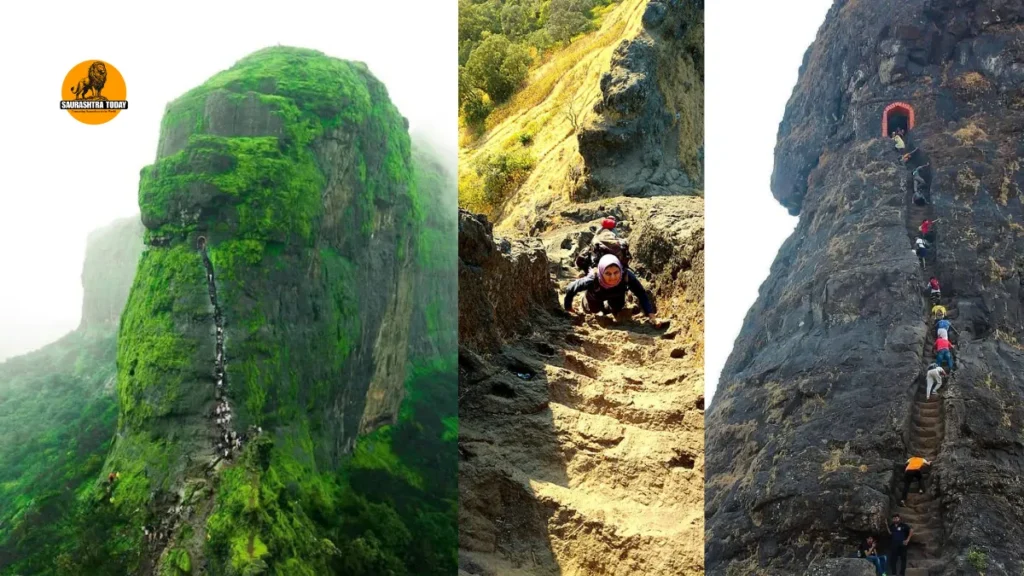
Harihar Fort, located in Maharashtra’s Nashik district, is one of the most striking hill forts in the Sahyadri range. Known for its unusual rock-cut staircase, steep climb and sweeping views of the surrounding mountains, the fort has become a popular destination for trekkers looking for a mix of history, adventure and natural beauty.
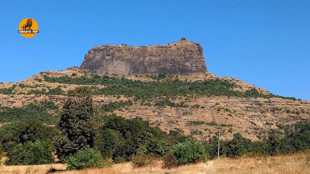
Situated in the Trimbakeshwar mountain range, Harihar Fort offers a trekking experience that is considerably different from an ordinary hill walk. From a distance, the fort appears almost rectangular, but its actual structure is built on a triangular prism-shaped rock. The nearly vertical sides of the hill and the narrow staircase carved directly into the stone are what make the trek particularly memorable.
The route is relatively short compared with several other challenging treks in Maharashtra, but that does not mean it is easy. The final section involves a steep ascent on rock-cut steps, making the trek demanding and, in some places, intimidating. The dramatic landscape, however, makes the effort worthwhile.
For visitors interested in Maharashtra’s forts, the destination offers an opportunity to experience both the region’s historical legacy and the rugged beauty of the Sahyadris.
Harihar Fort History
Harihar Fort, also known as Harihar Killa, stands in the Trimbakeshwar mountain range and has a history that goes back several centuries. The fort is traditionally associated with the Yadava Dynasty, which is believed to have constructed it between the 9th and 14th centuries.
The location of the fort was strategically important because of the trade routes that passed through the nearby Gonda Ghat. Like several hill forts in the region, its position provided an advantage for keeping watch over important routes and the surrounding countryside.
Over the years, Harihar Fort changed hands during various conflicts involving regional powers. The fort was also associated with the Ahmadnagar Sultanate. Its history is connected with the wider political struggles that took place across Maharashtra as different rulers competed for control of strategically important forts and routes.
In 1636, Shahaji Bhosale surrendered several forts to Khan Zaman. The group included Harihar as well as Trimbak, Tringalvadi and several forts in the Pune region. These developments formed part of the larger political changes taking place in the Deccan during that period.
The fort eventually came under British control. Today, however, Harihar Fort no longer serves a military purpose. Instead, it has become a well-known trekking destination, attracting visitors from Nashik, Mumbai, Pune and other parts of Maharashtra.
What Makes Harihar Fort Special?
The biggest attraction of Harihar Fort is its unusual construction. Unlike conventional forts built on broad hilltops, Harihar rises from a distinctive triangular rock formation.
Its vertical appearance can be seen clearly while approaching the fort. What initially looks like an almost impossible climb becomes a defined route once trekkers reach the base of the rock-cut section.
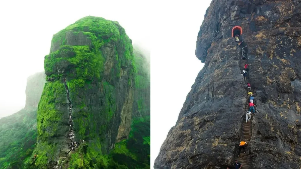
The staircase is the most famous feature of the trek. The steps were carved into the rock and rise steeply toward the fort entrance. In places, the climb becomes narrow, with steep drops alongside the route.
This combination of historic architecture, exposed rock and dramatic mountain scenery has made the fort particularly popular among adventure enthusiasts.
From higher sections of the fort, trekkers can enjoy panoramic views of the surrounding countryside and several nearby hills and forts. During the monsoon, the landscape becomes especially attractive as the Sahyadri hills turn green and streams appear along the trekking route.
Harihar Fort Trek: How Difficult Is It?
The Harihar Fort trek is generally considered a challenging trek despite its relatively short overall distance.
The difficulty increases significantly during the final section. The most demanding portion consists of steep rock-cut steps leading toward the entrance of the fort. According to the supplied trek information, the staircase section is around 200 steps and has an elevation of roughly 80 degrees in places.
The steepness means trekkers need to be careful, particularly while climbing down. One section is associated with a significant drop of around 500 feet, adding to the sense of exposure.
The staircase itself is an impressive example of rock-cut construction. Handholds and notches along the sides provide support, although some portions of the steps have become worn over time.
Rain can make the situation more difficult. The stone steps may become slippery during the monsoon, so footwear with a firm grip is essential.
For experienced trekkers, the challenging final climb is one of the main reasons to visit. For first-time trekkers, however, the steep section should not be underestimated.
Harihar Fort Trek Route
The trek can broadly be understood in two sections:
- Base village to the plateau
- Plateau to the fort and summit through the steep rock-cut steps
The route offers a noticeable change in terrain as trekkers move closer to the fort.
First Section: Base Village to Plateau
One approach begins near Kotamwadi village. From the village, the trail passes through agricultural fields before gradually moving uphill.
During the monsoon, the landscape along this section becomes particularly scenic. Paddy fields, green slopes and small streams can be seen along the route.
As the trail continues, it enters a forested area before eventually opening onto a ridge. The ridge provides a connection toward the fort and offers trekkers a chance to enjoy views of the surrounding landscape.
Small streams may be encountered during the rainy season, making the route more attractive but also potentially more slippery.
Another route starts from Harshewadi village. This approach is considered shorter and comparatively easier than the Kotamwadi route. The trail passes through forested sections and open clearings before reaching the plateau.
Trekkers generally choose their approach depending on their planned itinerary, transportation arrangements and the route conditions on the day of the trek.
Second Section: Plateau to Harihar Fort
The character of the trek changes once the plateau is reached.
From here, the distinctive vertical staircase of Harihar Fort becomes visible. Trekkers can also find a small shop near the plateau area where basic refreshments and water may be available.
The fort stands at the top of the large rock formation. The final ascent involves a long stretch of rock-cut steps, measuring around 60 metres according to the supplied information.
Some of these steps have been worn down over time. The notches cut into the rock provide handholds, but trekkers still need to maintain a steady pace and remain cautious.
The monsoon can make this portion particularly demanding because wet stone surfaces can become slippery.
The Mahadarvaja and Steep Staircase
The route reaches the historic Mahadarvaja, or main entrance, after approximately 90 steps.
Once through the entrance, the trail continues toward the left. A valley can be seen on one side while the fort wall rises on the other. Harshewadi village can also be seen from parts of this section.
One particularly interesting feature is the low ceiling along part of the route. Trekkers then encounter another set of steep rock-cut steps.
This second staircase is considered more challenging than the initial climb. It leads through a narrow section and eventually toward a cave-like chamber.
Trekkers need to negotiate roughly another 100 steps in this portion before reaching the upper section.
Cave Passage and Fort Summit
After climbing the steep staircase, trekkers encounter a cave-like area. A small opening or crawling passage leads onward toward the upper portion of the fort.
The route eventually opens into an area containing a small temple dedicated to Lord Hanuman and Shiva. A pond can also be found near the temple.
The surroundings provide an impressive perspective of Balekilla, the highest fortified section of Harihar Fort.
The trek does not necessarily end at this point. From the fort area, trekkers can continue for another 10 to 15 minutes to reach the highest point.
The summit is extremely narrow. According to the supplied information, there is room for only around two people to stand on the crest at a time. Because of the exposure and limited space, visitors should exercise considerable caution and avoid crowding the summit.
Harihar Fort Timings
The supplied information lists the Harihar Fort trek timings as 12:30 PM to 2:00 AM.
Trekkers should nevertheless plan their visit carefully rather than relying solely on the stated timing. Mountain conditions, weather, daylight, transportation availability and local conditions can affect the practical timing of a trek.
Starting early enough to complete the ascent and descent safely is particularly important for people unfamiliar with the route.
Is Permission Required for Harihar Fort Trek?
According to the information provided, trekkers do not need separate permission from the tourism or forest departments for the Harihar Fort trek.
Visitors should still follow local instructions, respect the fort and surrounding natural environment, and avoid leaving behind plastic or other waste.
The fort is both a historical structure and part of the natural landscape, so responsible tourism is important.
What Should You Carry for the Trek?
Proper preparation can make a major difference on Harihar Fort.
Trekkers should carry at least two litres of drinking water, along with a first-aid kit, glucose and any personal medicines they may require.
Food should also be packed in advance. High-energy, ready-to-eat snacks are useful because food and water availability along the route is limited. There is only a small shop in the plateau area after leaving the base villages.
A valid photo identification document should also be carried.
For a monsoon trek, quick-drying clothing is preferable to cotton shirts, which can remain wet for a long time. A poncho or rain jacket is useful during heavy rainfall, while an additional pair of socks can make the journey more comfortable.
Good trekking shoes with adequate grip are essential, especially for the wet rock-cut staircase.
A whistle can also be included in the trekking kit for emergency situations.
Choose the Right Backpack
A comfortable haversack or trekking backpack is more practical than a sling bag while climbing Harihar Fort.
The final section requires the use of both hands at certain points, particularly when negotiating steep steps and exposed sections. A bag that remains securely on the back keeps both hands available and reduces unnecessary movement.
Trekkers should also avoid carrying excessive weight. The goal should be to take essential supplies without making the climb unnecessarily difficult.
Public Transport and Return Journey
Transportation should be planned before beginning the trek.
According to the supplied information, public transport options toward Nashik and Trimbak become limited after around 3:00 PM. Trekkers should therefore consider their return arrangements in advance rather than assuming that frequent transport will be available after completing the trek.
Those travelling from outside the region may find it more convenient to organize transportation for both the onward and return journeys before starting the trek.
Who Should Avoid the Harihar Fort Trek?
The Harihar Fort trek should not be treated as a casual sightseeing walk.
The steep second section can be physically demanding, particularly for people who are not accustomed to climbing on steep terrain. The narrow rock-cut steps and exposed sections require confidence, balance and careful movement.
The trek is generally not recommended for beginners who have no prior trekking experience. People with medical conditions that could make strenuous physical activity or steep climbing unsafe should also avoid attempting the route without appropriate professional medical advice.
Weather conditions can further increase the difficulty. During heavy rain, slippery steps and reduced visibility can make the climb more challenging.
Best Time to Visit Harihar Fort
The period from July to February is considered a favorable season for visiting Harihar Fort, according to the supplied information.
The monsoon months are especially popular because the Sahyadri landscape undergoes a dramatic transformation. Hills and fields turn green, streams become more visible and the surrounding countryside looks fresh after the rains.
The rainy season also gives trekkers some of the most attractive views from the fort. Green valleys, distant peaks and nearby forts create a striking landscape from the upper sections.
However, monsoon trekking also comes with additional challenges. Wet stairs can be slippery, streams may become stronger and sudden rainfall can affect visibility. Trekkers should therefore balance the scenic appeal of the monsoon with the additional safety precautions required during the season.
From the post-monsoon months through winter, the weather can be more comfortable for trekking, while the landscape continues to offer attractive views.
Why Harihar Fort Deserves a Place on Your Travel List
Harihar Fort brings together several experiences in one destination.
For history enthusiasts, the fort provides an opportunity to explore a structure connected with the Yadava period, the Ahmadnagar Sultanate and the later political history of Maharashtra.
For adventure lovers, the rock-cut staircase provides the main challenge. The unusual design of the fort makes the ascent unlike many other treks in the Sahyadris.
For nature lovers, the surrounding landscape offers another major attraction. The views from the upper sections stretch across the hills and valleys of the Nashik region, with several prominent forts and peaks visible in favorable conditions.
The trek also provides a welcome break from busy city life. The combination of greenery, open mountain views, historic ruins and physical activity makes the journey particularly rewarding.
Read also: Mumbai Konkan RoRo Ferry: Routes, Timings, Ticket Prices & Complete Travel Guide
Conclusion:
Harihar Fort is more than just another fort near Nashik. Its unusual triangular rock formation, historic significance and famous vertical staircase have turned it into one of Maharashtra’s most recognizable trekking destinations.
The trek may be short compared with some long-distance mountain routes, but its steep final climb makes it a serious adventure. The rock-cut steps, narrow passages, dramatic drops and summit views all contribute to the experience.
Visitors planning the trek should prepare properly, carry enough water and food, wear suitable footwear and take extra care during the monsoon. Beginners should understand the difficulty of the route before setting out, while experienced trekkers will find plenty to enjoy along the way.
For anyone looking to combine history, nature and adventure in Maharashtra, Harihar Fort offers a memorable experience amid the Sahyadri mountains. The fort’s dramatic setting and distinctive staircase make the journey as important as the destination itself.
Read also: Ro Ro Ferry Surat to Bhavnagar Ticket Booking: Complete Guide, Timings, and Prices