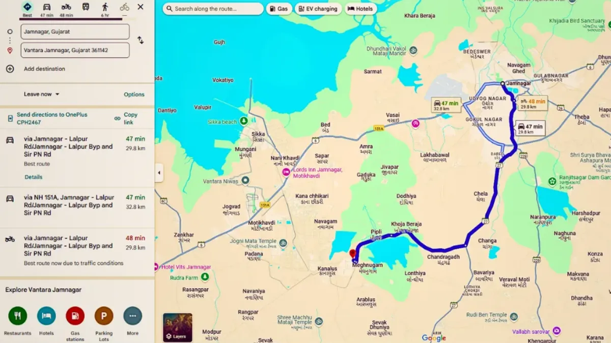
Vantara Map: your ultimate guide to discovering one of India’s most remarkable destinations that blends spirituality, wildlife conservation, and serene natural beauty. Whether you’re planning a visit or simply want to understand the vastness of this initiative, the Vantara Map helps you navigate its sanctuaries, rescue zones, temples, and wellness areas with ease.
What is Vantara?
Vantara, located near Ahmedabad in Gujarat, India, is a large-scale, world-class animal rescue, rehabilitation, and conservation project founded under the Reliance Industries initiative. Spread across thousands of acres, this sanctuary provides a safe haven for elephants, lions, leopards, reptiles, and countless other rescued species. The project’s name, “Vantara,” translates to “Star of the Forest,” perfectly symbolizing its purpose — to protect and heal nature’s treasures.
Why the Vantara Map is Important
The Vantara Map is an essential resource for anyone interested in exploring or learning about this massive facility. Given the vast area Vantara covers, the map helps visitors and researchers understand how different sections — from animal rescue centers to wellness retreats — are connected. It also highlights key points of interest like rehabilitation areas, veterinary centers, and meditation spaces.
By using the map, visitors can plan their route more efficiently and ensure they don’t miss any major attractions within the sanctuary. It’s also a valuable educational tool that gives insights into Vantara’s approach to sustainable wildlife management and spiritual harmony.
Key Zones Shown on the Vantara Map
The Vantara Map outlines several well-defined zones, each serving a unique purpose. Below is a table highlighting the main sections and their significance:
| Zone Name | Purpose / Highlights |
|---|---|
| Wildlife Rescue Zone | Dedicated to rescuing and rehabilitating injured or abandoned wild animals. |
| Elephant Sanctuary | A safe, natural habitat for rescued elephants, offering open spaces and water bodies. |
| Veterinary & Research Center | Provides world-class medical care, nutrition, and research for animal welfare. |
| Spiritual Retreat Area | Designed for meditation, yoga, and spiritual rejuvenation amid nature. |
| Herbal & Botanical Gardens | Home to rare medicinal plants and herbs promoting ecological balance. |
| Visitor Education Center | Offers exhibitions and information about conservation, wildlife, and sustainability. |
Also read: Pradyuman Zoological Park Rajkot: A Record-Breaking Visitor Rush During Diwali Holidays
How to Use the Vantara Map
Using the Vantara Map is simple yet insightful. It provides an overview of walking paths, guided safari routes, and restricted conservation areas. Visitors can explore the layout to understand the distances between various attractions, locate eco-friendly transport routes, and identify rest zones and observation points.
Since not all areas are open to the general public — especially sensitive animal recovery sections — the map helps visitors plan their experience responsibly while respecting the sanctuary’s ecosystem.
Also read: Lion Safari Park Rajkot: What Will Be the Ticket Price and When Will It Open?
Educational and Environmental Value
The Vantara Map is more than a navigation tool — it’s an educational document that showcases the depth of India’s commitment to animal welfare. Schools, NGOs, and wildlife enthusiasts can use it to study habitat design, conservation practices, and modern eco-tourism. The layout reflects a perfect balance between human interaction and wildlife preservation, making Vantara a global example of sustainable development.
Visiting Vantara Using the Map
Currently, public visits to Vantara are limited and regulated to protect rescued animals. However, when visits are permitted, the map serves as a virtual tour guide — allowing you to explore the lush forests, water bodies, and peaceful spiritual zones. Travelers and pilgrims visiting nearby temples or eco-spiritual destinations can also use the map to understand Vantara’s location and connectivity with the surrounding areas of Gujarat.
Also read: Lion Safari Park Rajkot: Gujarat’s Next Major Wildlife Destination Set to Open by April 2026
Conclusion
In essence, the Vantara Map is a gateway to understanding one of India’s most visionary projects that intertwines compassion, spirituality, and conservation. It not only helps visitors navigate the sanctuary but also spreads awareness about the harmony between humans and nature. As Vantara continues to grow, its map stands as a symbol of how thoughtful design can guide humanity toward a greener, kinder future.
In short: Whether you are a researcher, a nature lover, or a spiritual seeker, the Vantara Map is your key to exploring this divine sanctuary with purpose and awareness.